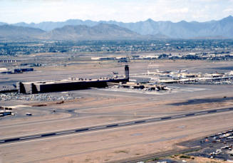
40" x 62" Aerial Photography Map of Sky Harbor
Maker
City of Phoenix
DateOctober 1989
MediumPaper
Dimensions11 x 8 1/2 in. (27.9 x 21.6 cm); Small
ClassificationsDocumentary Artifact
Credit LineTransferred by City of Tempe Public Library
Catalog number2000.28.1538
DescriptionA 40" x 62" aerial photgraph map of Sky Harbor Airport in two sectionsStatus
Not on viewPhoenix Sky Harbor International Airport - Master Plan Update Concepts
2/10/1989
c. 1985