

City of Tempe Street Map
Date1961
MediumPaper
Dimensions15 x 16 in. (38.1 x 40.6 cm)
ClassificationsDocumentary Artifact
Catalog number2007.15.3
DescriptionThis tan map shows Tempe in 1961 with schools, ASU and Buttes marked. The future high school site for McClintock is shown. Town boundaries are delineated by heavy black lines. The map goes from 48th St. to east of Price and above McKellips to Baseline. Papago and Shalimar Golf courses are shown. The railroads are S.P. shown above Broadway. origin: Tempe. Maker: Chamber of Commerce of Tempe.Status
Not on viewCollections

c. 1970


February 23, 1978

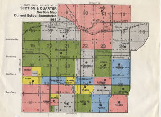
November 1985

November 1985